Levels of Bushfire Attack

A Bushfire Assessment of your new house will put it in one of the following 6 levels:

Bushfire Attack Level

(BAL)

Description of Predicted Bushfire Attack and Levels of Exposure

BAL – Low

There is insufficient risk to warrant specific construction requirements

BAL – 12.5

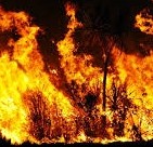
Ember attack (Burning twigs, branches or leaves  airborne and carried  on the wind ) with heat flux* up to 12.5kW/ m2 (Heat flux = Amount of heat transferred per unit area per unit time to a surface)

BAL – 19

Increasing levels of ember attack and burning debris ignited by windborne embers together with increasing heat flux between 12.5 and 19 kW /m2 

BAL – 29

Increasing levels of ember attack and burning debris ignited by windborne embers together with increasing heat flux between 19 and 29 kW m2

BAL – 40

Increasing levels of ember attack and burning debris ignited by wind borne embers together with increasing heat flux (29 – 40 kW/m2) with the increased likelihood of exposure to flames

BAL -FZ

Direct exposure to flames from fire front in addition to heat flux and ember attack

*As a comparison the Heat flux from the Sun is around 400 W/m2.


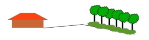
Remember these levels are based on the BAL when the house is being planned. If you build and then fill the garden with shrubs and trees a few years later the Level, and the Risk, will be higher!


Don’t think that because you are in a suburb that you will be automatically be in a ‘BAL Low’ Area. Some suburban areas can still be at risk!


What Is The Bushfire Attack Level explains what factors are used in the Assessment


What is the Bushfire Attack Level (BAL)

The BAL is a number that indicates how severely a bush fire is likely to affect your new house. It comes from the Australian Standard AS3959 – 2009.

The number is calculated by considering the following  factors:

  1. The Fire Danger Index (FDI)   The probability of a bushfire starting, speed of spread, intensity and difficulty of fighting the fire.For Victoria the FDI is 50 for an alpine area or 100 elsewhere. For other states you will need to check with your state regulations.
  2. Classification of Nearest Vegetation   In all directions. 
    • A – Forest
    • B – Woodland
    • C – Shrubland
    • D – Scrub
    • E – Mallee / Mulga
    • F – Rain Forest
    • G – Grassland
  3. Distance to Vegetation   Horizontal distance to the main part of the house.
  4. Slope   This is the slope of the vegetation, not the slope of the area between the vegetation and the house.

In the above example this is a ‘Down Slope’ as the slope of the vegetated area is Down as it goes away from the house ((Even though the intervening space slopes up). ‘Down Slopes’ are higher risk than ‘Up Slopes’ because fire moves quicker going up hill.

By the use of tables the FDI can be calculated for each direction with the highest value being the overall FDI.

Although it is possible to get guides and do it yourself (For example: Victorian Building Authority) I think where safety is involved it’s worth getting an expert in. They will be able to do the assessment and give you advice on requirements and improvements.


This link explains the various BAL ‘Scores’

Exit mobile version