Understanding your Survey Plan

I’m used to look at survey plans but I do understand that most people struggle to understand them.

Here is a quick guide to help you understand the survey plan for your new house.

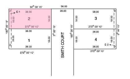
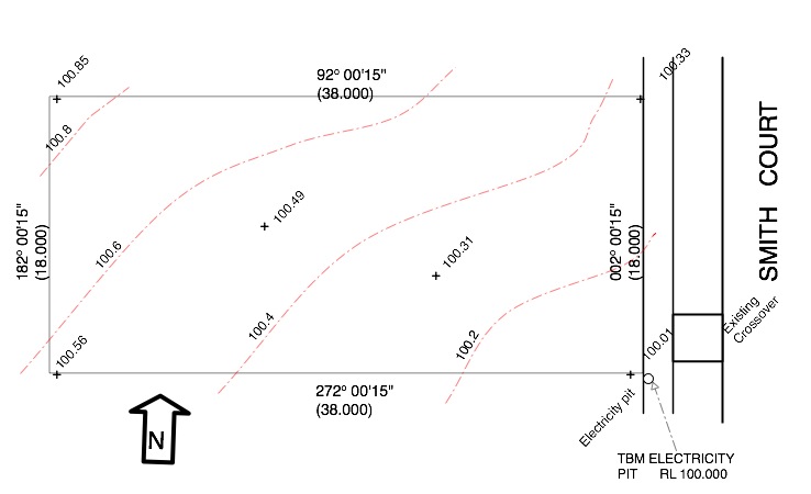
The plan below shows a survey plan, with a North Point, has been provided.for the block previously mentioned in the Title Plan Post. It doesn’t include the easement to make it easier to see the other details.

The bearing and length of each boundary are the same as the title plan in the format.

For example the North boundary is at bearing of 92 degrees 0 minutes 15 seconds (92° 00′ 15″) and 38m long.

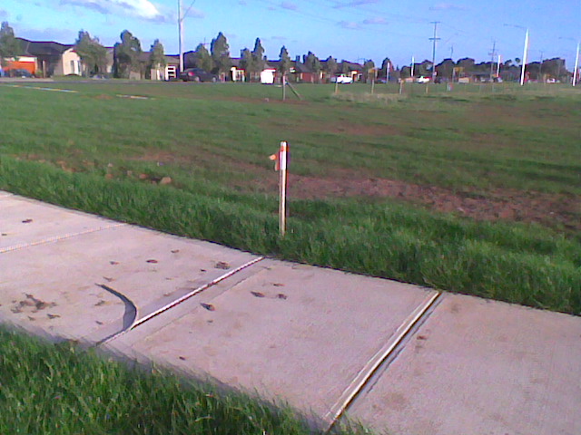
The footpath along the front of the block and the nature strip crossover (constructed by the developer is shown, as well as an electrical pit.

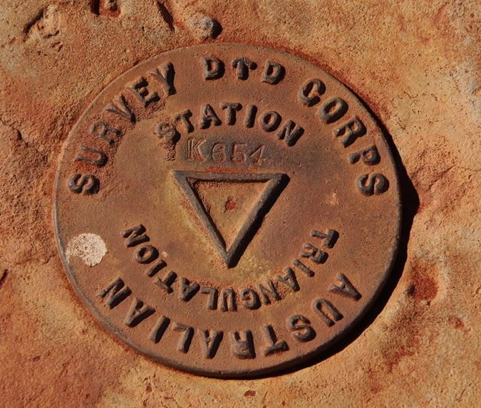
TBM stands for Temporary Bench Mark.

This means the surveyor will use this feature as the level on which all other level information such as slab levels will be based.

It is normal for the TBM to be set at a round number typically either 10.000m or 100.00m.

Usually the only time the TBM’s actual height will be the correct height above Sea Level (Australian Height Datum) is when there is a risk of flooding and the floor level will need to be above the 100 year flood level.

Once the TBM has been set the surveyor calculates the surface levels of the block.

This is shown by contours, (shown dashed) which are lines of equal height.

The normal contour interval for residential block surveys is 0.2m intervals and each contour is labelled with the height it represents.

In addition to the contours the surveyor will show spot levels at the corners and sometimes in the middle of the block. (These are marked with a ‘+’ and a height)

From this drawing you can see:

  • The lowest part of the block is the South East corner at 100.00m
  • The highest part of the block is the North west corner at 100.85m
  • The block slopes upwards from the front at approx 0.53m. (around 1 in 70)
  • The block slopes upward in a Northerly direction at approx 0.30m (around 1 in 60)
  • As the contours are roughly similar spacing from each other the slopes are fairly constant.


In summary although there is a slope on the block it isn’t too severe so the site costs for dealing with the slope could be around $4- $6,000.


For more see Blocks


Understanding Title Plans

Title plans are quite a bit different to Survey Plans.

The above is typically what you would see when looking at the title plan for a small subdivision.

This is what it tells you about block No 2, which I have coloured in pink.

  • The total width of the Road Reserve of Smith Court including nature strips and future footpaths is 20m.
  • The *survey grid bearing for Smith Court at the front of the block, is 2 degrees 0 minutes and 15 seconds (200’ 15”) almost due North.
  • The width on the road frontage is 18.00m.
  • The top boundary runs at a bearing of 92 degrees 0 minutes and 15 seconds (9200’ 15”) which is almost due East for a distance of 38.00m (the depth of the block is therefore 38m)
  • The rear boundary runs at a bearing of 182 degrees 0 minutes and 15 seconds (18200’ 15”) which is almost due South for a distance of 18.00m. so the width at the rear of the block is also 18m.
  • The bottom boundary runs at a bearing of 272 degrees 0 minutes and 15 seconds (27200’ 15”) which is almost due West for a distance of 38.00m (the depth of the block is therefore consistent at 38.00m)
  • There is a 2m wide Easement at the rear of the Block Labelled E-I. This means it will be VERY difficult to build on this part of your Block.

Within the title documents you will find a reference to each easement on the subdivision saying what the easement is for.

Generally you will be lucky if there are no easements as over 50% of blocks will have at least one easement

Each corner of the site should be marked with a Boundary Peg which needs to be protected from damage.

*ASurvey Grid Bearing’ is a fixed direction unlike a bearing from Magnetic North which can change over time.


For similar posts see Block Dimensions

To find out about Easements see Restrictions

Block Boundary Pegs

Your block location is defined by its boundary pegs.

It all looks quite simple when you are looking to buy the block. You can go out to the site and see tall pegs with tape at every corner.

A few months later when the builder is looking to start it can all be very different.

The pegs may have been stolen, or damaged, and your builder will be asking for $800 or more to re-establish the site boundaries.

Here is how you might save that money………………….

The first thing to understand is the tall pegs are indication markers, the actual boundary peg is normally driven down to just above ground level. (See photo below)

While the pegs are still obvious

    • Take measurements so you can find or relocate the pegs accurately, this involves taking measurements to each peg from at least two points that are unlikely to be damaged. Examples are joints in concrete paths, drain covers, existing fences.
    • Where possible you can use paint to mark concrete paths or fences.
    • Make sure the boundary peg is knocked down to ground level.
    • Cover the peg with gravel or sand so it looks different to the surrounding soil.
    • You should now be able to find the boundary pegs, even if the marker pegs go missing.
    • Don’t worry if one peg goes missing the builder only needs three pegs to do their set out.

If you want more information its worth reading the post on Reading Title Plans


For similar posts see Blocks

How Close Is Too Close

Here is a photo from the ABC Brisbane facebook page

I would say this is far to close.

That space is just going to be a collecting point for spiders and vermin.

I really don’t see the point of wanting a detached house and then having it look like a terraced house.

It is really going to hit the resale value as well.

Recommendation

A good rule of thumb if you want to avoid something like the above photo is plan for a house 2m narrower than the block.

That means you can have a 1m path on either side


AHD or TBM

Photo from www.exploroz.com

Some a site plan will say the levels relate to AHD and other times the levels will relate to a TBM . .. but what is the difference?

AHD – Australian Height Datum

Between 1966 and 1968 sea level was measured at 30 sites around Australia.

Based on these measurements a Mean Sea Level was assigned for each point.

From the individual points a mean sea level for Australia was established for Australia and given the level 0.000m AHD.

This has allowed the establishment of levels at thousands of points across Australia. (The photo shows a typical survey marker)

All surveys which are available to the public (For example: Flood Level Predictions, must show levels based on AHD)

Interestingly the sea level can vary considerably from AHD depending where you are in Australia.

An example would be the Gold Coast where the following applies:

  • Mean Sea Level 0.850m AHD
  • High tide 1.890m AHD (Mean High Water Springs)
  • Low tide 0,23m AHD (Mean Low Water Springs)

TBM – Temporary Bench Mark

There is an expense in transferring a level from a survey point to your block so your block can be surveyed with AHD levels and contours.

This will vary from a few dollars to hundreds of dollars depending on how close the block is to a survey marker.

Unless the survey company is aware of the need for the survey to be based on AHD levels they will base their survey on a TBM to save you money.

They will normally assign a level to the corner of a drain grate or inspection cover frame. Typically this will be a round number such as 10.00m or 100.00m.

If you need the levels changed to AHD at a later stage they can extend the survey to calculate the AHD level at the TBM and then adjust the levels.


Access to Rear

With the narrow blocks that are becoming more common you see a lot of new houses built right to the side boundary on both sides.

In some cases that can’t be avoided, but I think there is a real advantage in buying a block with enough room for a path on at least one side of the house, preferably both sides.

Here’s some reasons why:

  • There will be extra costs for special wall and roof details, constructing foundations, and building walls on the boundary.
  • You might have ongoing property maintenance issues if you fall out with your neighbour.
  • If you need to do some gardening you can avoid taking top soil, plants and other dirty things through the garage, or even the house, if the garage doesn’t have a back door.
  • Many properties have drainage or sewerage easements with a Manhole (or in these politically correct time an access pit). If the council/water authority needs access you may need to take time off work rather than just leave a gate open for the day.
  • If you have a dog in the back yard then looking through a gate helps to stop them getting bored while you are out at work.
  • If you want a detached property why have it looking like a terrace?

Perhaps there are some advantages of building to the boundary. If you have found any let me know.

For more things to think about when buying a block see:

Guide to Buying a Block

How Adverse Possession Can Affect Buying A Block

Did  you know its still possible to take over ownership of someone else’s private land?

This makes it important to check the Land Title Plan dimensions against the actual site dimensions of your new house block for the following reasons:

  • If the actual dimensions are bigger it doesn’t mean the seller owns the ‘extra’ land unless they can demonstrate adverse possession.
  • If the land is smaller a neighbour may have ‘acquired’  ownership by adverse possession.

Either way you could be in for a considerable amount of legal costs to get the ownership of the land sorted out.

Adverse Possession

Adverse Possession is when someone becomes the owner of land through continued exclusive use of that land.

Limitation Period

Before land can be obtained by adverse possession there has to be continued use use of the land for an extended period. That period is different for the various states as follows:

  • Victoria, 15 years
  • South Australia, 15 years
  • New South Wales, 12 years
  • Western Australia, 12 years
  • Tasmania, 12 years
  • Queensland, 12 years

Crown (Government) Land

With the exception of New South Wales and Tasmania you cannot claim Crown Land. In those two states a longer (30 year) limitation period applies.

The reasons are that it is harder for a government to keep an eye on its lands, and it is assumed that the government hold possessions for the public good, despite any apparent neglect.

How Adverse Possession Claims Work

Adverse possession means not mere occupation but also actual physical possession in an open and peaceful manner, without consent of the original owner.

Any form of permission ( a licence, a lease, or an agreement to use the land), and the claim of adverse possession will fail because it will be clear that the owner gave consent for use with no intention to pass over ownership.

Proof to the Titles Office in your State that the land has been  occupied for the entire period of time is required.  

Evidence will be, that as a minimum, at least one of the following has occurred for the whole of the limitation period :

  • A secure fence has been in place without challenge ;
  • ‘Keep Out, Private Land’ signs have been erected without challenge;
  • Payment of rates and taxes.

The information in this post is of a general nature and you should not try to deal with adverse possession issues without involving a lawyer.


For more Information why not look at: anewhouse Guide to Buying a Block


Buying a Block

anewhouse GUIDE  – E book

 Aimed at making sure you consider a wide range of issues to ensure you get the right block for your new home!

Posts from this Blog and Much More.

In pdf format so you can read it on your tablet computer.

82 pages packed with advice  including Comprehensive Checklists that can be printed out.

Reduced . . . Now Only $2


CLICK HERE for more details


What Sort of Plan?

Buying Land…….There are several sorts of Plans/ Surveys of your Block to think about before you can start building a house.

Here is a guide to the various plans based on the same block:

Title Plan

Title Plans are the legal document that describes the land. Initially they are usually the only plan that is available  They are limited to:

  • Showing the dimensions and bearings of the boundaries.
  • Showing the locations of Easement.

The drawing below is a typical title plan

Feature Survey

The Feature Survey is an accurate representation of the block prepared by a surveyor. Typically the information shown is:

  • Boundaries.
  • Site Contours.
  • Locations of trees.
  • Any other above ground features such as driveway crossovers and manholes.

If you buy direct from a project builder they will normally arrange the feature survey. If you want to get quotes from several builders it can be worth getting a feature survey done first.

Geo-Technical Plan

The Geo-Technical Plan is more in the form of a sketch than an accurate representation of the site. The main purpose is to indicate the approximate location of boreholes. Other information that may be included is:

  • Indication of location of trees as these may affect the Geotechnical Recomendations.
  • Any rock outcrops.
  • Direction of fall.
  • Ponds / swampy areas.


See Blocks for more information on buying land.


Exit mobile version