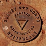
AHD or TBM

Photo from www.exploroz.com
Some a site plan will say the levels relate to AHD and other times the levels will relate to a TBM . .. but what is the difference?
AHD – Australian Height Datum
Between 1966 and 1968 sea level was measured at 30 sites around Australia.
Based on these measurements a Mean Sea Level was assigned for each point.
From the individual points a mean sea level for Australia was established for Australia and given the level 0.000m AHD.
This has allowed the establishment of levels at thousands of points across Australia. (The photo shows a typical survey marker)
All surveys which are available to the public (For example: Flood Level Predictions, must show levels based on AHD)
Interestingly the sea level can vary considerably from AHD depending where you are in Australia.
An example would be the Gold Coast where the following applies:
- Mean Sea Level 0.850m AHD
- High tide 1.890m AHD (Mean High Water Springs)
- Low tide 0,23m AHD (Mean Low Water Springs)
TBM – Temporary Bench Mark
There is an expense in transferring a level from a survey point to your block so your block can be surveyed with AHD levels and contours.
This will vary from a few dollars to hundreds of dollars depending on how close the block is to a survey marker.
Unless the survey company is aware of the need for the survey to be based on AHD levels they will base their survey on a TBM to save you money.
They will normally assign a level to the corner of a drain grate or inspection cover frame. Typically this will be a round number such as 10.00m or 100.00m.
If you need the levels changed to AHD at a later stage they can extend the survey to calculate the AHD level at the TBM and then adjust the levels.
Pingback: CAROL
No the site is based on a wordpress theme with minimal extra coding.