I’m used to look at survey plans but I do understand that most people struggle to understand them.
Here is a quick guide to help you understand the survey plan for your new house.
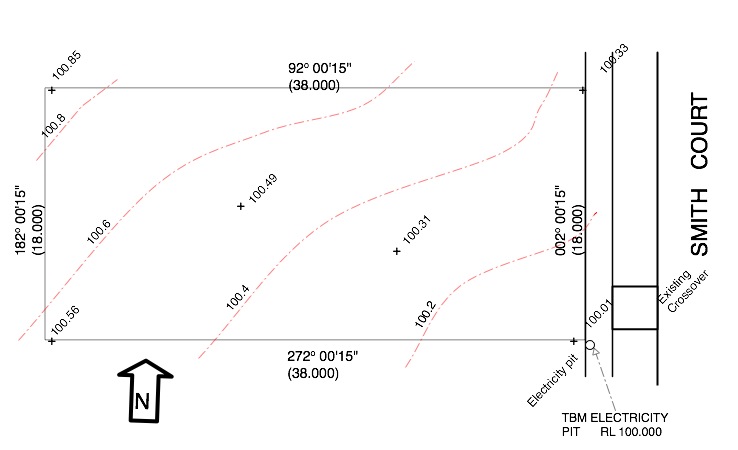
The plan below shows a survey plan, with a North Point, has been provided.for the block previously mentioned in the Title Plan Post. It doesn’t include the easement to make it easier to see the other details.
The bearing and length of each boundary are the same as the title plan in the format.
For example the North boundary is at bearing of 92 degrees 0 minutes 15 seconds (92° 00′ 15″) and 38m long.
The footpath along the front of the block and the nature strip crossover (constructed by the developer is shown, as well as an electrical pit.
TBM stands for Temporary Bench Mark.
This means the surveyor will use this feature as the level on which all other level information such as slab levels will be based.
It is normal for the TBM to be set at a round number typically either 10.000m or 100.00m.
Usually the only time the TBM’s actual height will be the correct height above Sea Level (Australian Height Datum) is when there is a risk of flooding and the floor level will need to be above the 100 year flood level.
Once the TBM has been set the surveyor calculates the surface levels of the block.
This is shown by contours, (shown dashed) which are lines of equal height.
The normal contour interval for residential block surveys is 0.2m intervals and each contour is labelled with the height it represents.
In addition to the contours the surveyor will show spot levels at the corners and sometimes in the middle of the block. (These are marked with a ‘+’ and a height)
From this drawing you can see:
- The lowest part of the block is the South East corner at 100.00m
- The highest part of the block is the North west corner at 100.85m
- The block slopes upwards from the front at approx 0.53m. (around 1 in 70)
- The block slopes upward in a Northerly direction at approx 0.30m (around 1 in 60)
- As the contours are roughly similar spacing from each other the slopes are fairly constant.
For more see Blocks
