Understanding Title Plans
Title plans are quite a bit different to Survey Plans.
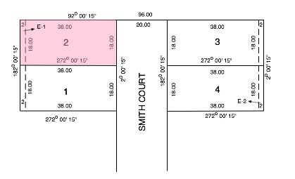
The above is typically what you would see when looking at the title plan for a small subdivision.
This is what it tells you about block No 2, which I have coloured in pink.
- The total width of the Road Reserve of Smith Court including nature strips and future footpaths is 20m.
- The *survey grid bearing for Smith Court at the front of the block, is 2 degrees 0 minutes and 15 seconds (2o 00’ 15”) almost due North.
- The width on the road frontage is 18.00m.
- The top boundary runs at a bearing of 92 degrees 0 minutes and 15 seconds (92o 00’ 15”) which is almost due East for a distance of 38.00m (the depth of the block is therefore 38m)
- The rear boundary runs at a bearing of 182 degrees 0 minutes and 15 seconds (182o 00’ 15”) which is almost due South for a distance of 18.00m. so the width at the rear of the block is also 18m.
- The bottom boundary runs at a bearing of 272 degrees 0 minutes and 15 seconds (272o 00’ 15”) which is almost due West for a distance of 38.00m (the depth of the block is therefore consistent at 38.00m)
- There is a 2m wide Easement at the rear of the Block Labelled E-I. This means it will be VERY difficult to build on this part of your Block.
Within the title documents you will find a reference to each easement on the subdivision saying what the easement is for.
Generally you will be lucky if there are no easements as over 50% of blocks will have at least one easement
Each corner of the site should be marked with a Boundary Peg which needs to be protected from damage.
*A ‘Survey Grid Bearing’ is a fixed direction unlike a bearing from Magnetic North which can change over time.

Bullet point 2 is not a compass bearing but a survey grid system bearing.
Magnetic north changes over times, but not survey grid systems or we’ll have people fighting over boundaries all the time. Excellent article.
Good point thank you. . . . . now changed.
Brian